
B&NES Regional Spatial Strategy
What Is It?
At present the Regional Spatial Strategy is still in draft, though by now a fairly mature draft. It covers the whole of the area in which the South West Regional Assembly has an interest.
We will, over time, try to extract the parts that are relevant to Bath, but if you want to read the documents that are available, they can be found on the council website.
of immediate interest though are the folllowing, as printed in Council News:
The Council thinks that achieving the delivery of growth while protecting and enhancing Bath's environment is the key strategic issue for the City. Maximum use of development opportunities within the City will help reduce the amount land in the green belt that needs to be developed. At the same time we want to avoid 'town cramming'.
The Regional Spatial Strategy proposes that housing that cannot be accommodated within Bath should be met by an 'urban extension' to the City. This will entail change to the boundary of the green belt. The Regional Spatial Strategy identifies the south and west of Bath as the most suitable area for an urban extension - this 'area of search' is illustrated in the map below. Not all of this area will be developed, but this is the area where the Council will focus its attention.
We suggest other major challenges for Bath include:
- Protecting and enhancing Bath's unique character
- Accommodating economic growth and creating more jobs
- Providing affordable housing including social housing and homes with shared ownership
- Meeting shopping needs (in the city centre and neighbourhood centres for day to day shopping)
- Maintaining Bath as an important visitor destination
- Impact of the expansion of the Universities and student accommodation
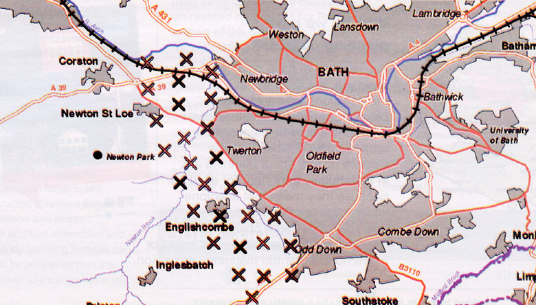
Illustration of the 'area of search' for Bath urban extension from draft Regional Spatial Strategy
The rational for the choice of area of search is obvious from this map:

As this area map shows, the chosen area is the only area around Bath that is not designated an area of Outstanding Natural Beauty. Bath's target in the Regional Spatial Strategy is 6000 additional homes. That implies a very large encroachment on the Green Belt.